|
Home
Kalimantan
Sulawesi
Halmahera |
|
Area: 17 780 square kilometers Highest point: 1635 meters Population: 163 000 The population density: 9,152 people / square kilometers |
|
Halmahera |
 |
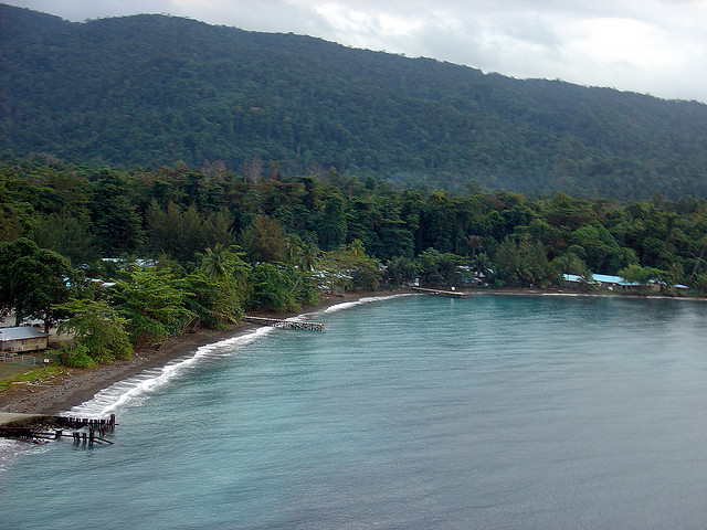
Halmahera - an island in the Malay Archipelago, the largest of the Moluccas, Indonesia belongs. Area of the island is 17,780 square kilometers. For the island is characterized by mountainous terrain (altitude up to 1635 m - an active volcano Gamkunoro). The climate is equatorial. Throughout the year, the temperature on the coast is 25-28 ° C, precipitation falls about 2000-3000 millimeters per year. The main component of the flora of the island is the evergreen forests. The island development of tropical agriculture, there are coconut plantations. On the island is gold, nickel and cobalt. The island's population of 162 728 people (1995). Population about equally divided into Muslims and Christians (according to other sources 80% Muslims and 20% Christians). During the Second World War on Halmahera was a Japanese military base. In 1999 and 2000 on Halmahera were violent clashes between Christians and Muslims. In religious conflict killed thousands. |
|
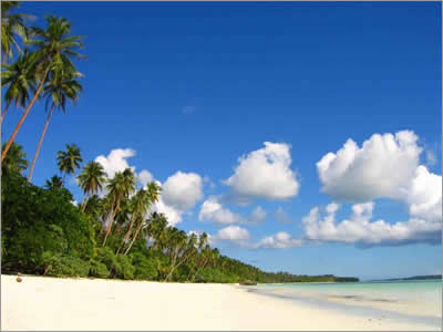
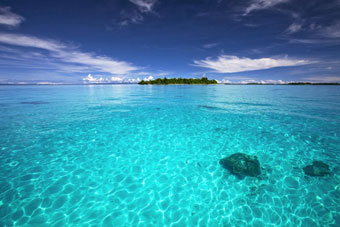
Features of the island Halmahera: 1) Thick pristine equatorial forests, home to a huge community concerns qty of unique flora and fauna; 2) Volcanoes, some of which are still in force; 3) The presence of dozens of islets; 4) The center of the "triangle of coral", a perfect place to explore the underwater world; 5) Rarely visited place, the place where you can see life and the life of the Indonesian people as they really are; 6) Place 11 years ago, which has suffered from sectarian clashes between Christians and Muslims. |
 |
|
Journey to the Halmahera island |
|
|
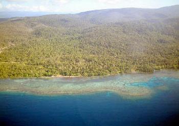
On the other side of the Strait of Halmahera (historical name - Gilolo, Djilolo) can see a blurry dark green spot in a thick haze. So far, more than 70% of the island is covered by rain forests, most of which are primary. The area in general is relatively low, but slides and hills up to 500 meters high - a great many. The highest volcano - Gunung Gamkonora reaches a height of over 1,600 m and is one of the most active volcanoes in the Moluccan Islands. Electricity on Halmahera until the beginning of XXI century, it was a luxury - only in the largest cities and nickel mines so gold was secured centralized supply of electricity, and large villages had diesel generators. From the time of Dutch rule in the Halmahera not typical of New Guinea forest semi Stone Age settlements - the Moluccas people live in wooden or stone houses, wear European clothes. The population density is very low (in Indonesian standards), as compared with Java or Sumatra. Prior to 1999, the Moluccas tacitly considered a role model for the peaceful coexistence of Christian and Muslim cultures and religions. Some even help others build their churches and houses of worship. But in the late 90's in Indonesia suddenly occurred a religious conflict, which is known to have grown out of nonsense. The bus driver - something touched Christian Muslim youth. Scuffle ensued. The result was a long-term massacre that claimed thousands of lives and displaced hundreds of thousands of beautiful islands. If, before the start of the conflict (as it |
 |
|
Maluku Islands |
| is called neutral in Indonesia - "conflict"), each of the communities was about half the population of the archipelago, and now in some islands of the Christian population is not left at all, and on the other the number dropped to about a quarter of the total. It is clear that the basis of all - the economy, which in the late 90's in Indonesia simply collapsed. But those who were in any part of the leverage to create focus did not fail to take advantage of it. The island until 2004 remained closed to foreign tourists. To this day in some parts of the second largest island of the archipelago - Pulau Seram do not let visitors - the conflict is not over yet. Nature Halmahera poorly understood. More precisely - has not been studied nearly all, especially invertebrates. By the way, to find a more or less detailed and current map of the island is almost impossible. | |
 |
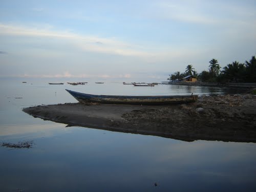
Sufifi is sufficiently large settlements and significant port for communication with the rest of Indonesia. Forests are not visible - in the lowlands of the island only, homes and plantations. Remote district center Weda, which is the "capital" of the nickel production on the island, located on Sufifi at 100 kilometers. This way you can drive in Isuzu Panther, a local "public" transportation, along with the two drivers. Two drivers are needed for the following purposes: in case of failure - one of the crew members remained in the car while the other wanders to the nearest village (it is often tens of kilometers) for help. Other "hazards" on the island there is little - about none of the local criminals and not heard. The first half of the way the road is a good or very good, new asphalt, holes virtually none. It winds along the coast of almost endless villages and coconut plantations. No wood at all - again a disappointment! Could not understand - as in a wilderness brought pavers ... At the entrance and exit of each of even the smallest village - "speed bumps." These obstacles are made of cement poured over sawn trunks of coconut trees. Electricity is central to everywhere. Over 3 years to electrify even the most remote mountain villages. Electricity is charged by the state, it is free for Aboriginal. |
|
Electricity is connected at 18 o'clock in the evening and off in the morning about 6 hours. On the road, you can find a lot of animals: chickens, cats, cows and goats. By the way, just so you can quickly figure out which village - Christian or Muslim - we were. If there is a dog - a Christian village (dogs Muslims do not eat, and the Christians they do just this "feature" when the sea is stormy and the fish do not go out to the reefs.) I f is on the road are a goat, you can immediately tell that this is - Muslim village. Christians prefer pigs and cows. While crossing a narrow isthmus hilly Southern Peninsula Halmahera, the road goes sharply to the left and up. How radically changed landscape outside the window - these were the primary mountain forest! Along the way flocks of cockatoos and flying hornbills, and if you look down, you can admire the blooming orchids. From a hilltop offering fantastic views of the pristine forests - it seems, to the horizon. Speed of movement is much reduced; there are many obstacles on the way (well one after the other). Journey takes more than 6 hours. Season without rain ("Dry Season") on the island almost justifies its name. During this brief period of rain and only 2-3 times a week, and in the rainy season, rain falls all day, blurs the road and get to the remote settlements becomes completely impossible. |
|
 |
W e d a |
 |
|
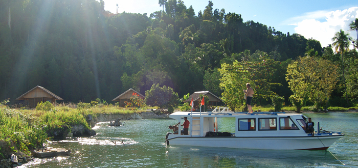
Weda is a small regional center, with a population of about 2-3 thousand people, but to actively frustrating suburbs, resulting in all the surrounding forest completely cut down and surroundings are an eerie sight. The first issue of the first counter is: "You are a Christian?" After receiving an affirmative response, a local resident immediately asked a second question: "And you're not a terrorist?" Weda - too pure Muslim settlement, and "conflict" are still deep in the blood of the local residents. Indirect and direct reminders of the conflict can be found throughout the trip around the island. Moreover, both parties believe it is in their own right and in contact with the other side doing not go. Moluccas well blown by winds, large marshes there, mangroves, though many, but they are located in a narrow strip along the low-lying parts of the coast A trip to the almost traditional Moluccan canoe - hollowed from a single trunk of a huge tree, but with a petrol engine - across Weda takes the bay to Tilope a half hour. Swim, boat passes along the picturesque banks (here they are rocky, so all the old wood covered) over coral reefs and through the Straits of mangrove islands. Far away on the shore of a small picturesque backwater village you can see Loleo, and 100 m to the south - a young, newly built Tilope (new home of the former Christian community Loleo, which is now home to a Muslim). Tilope consists of two parallel streets, lined wooden houses Aboriginal and beautiful gardens. The cabins are all the same, built by the state. During the "conflict" the inhabitants of the village for nearly three years hiding in nearby forests, in caves (which we later also visited). State in exchange for guarantees of non-resettlement Tilope on the already congested Greater Sunda Islands rebuild their village held a sewer and light, even erected a church and school. At home, as a consequence, all exactly the same. Each village has a school, a Christian church, and his police officer who is a representative government. Around the village, as one would expect, a few miles are laid in the time of Dutch rule coconut plantations and gardens. Coconut palms is 60-80 years old, told the local people. Production of copra and timber - is virtually the only source of income for the local population. However, after some time here, it is possible to realize one very interesting feature - the money is not needed anyone. They have nothing to spend. Is that gasoline for motorbikes, cigarette (smoking is everything - from the women and children, old men to gray), arrack (local variety of weak rice moonshine - actually, mostly for Christian villages). Since the Moluccas is not urgent problem of overpopulation, the sea provides sustenance for every single one, and the vegetables and fruits from the orchards and plantations significantly diversify the diet of local people. |
|
|
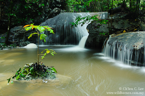
River Air Tilope begins in the mountains of the region Oham and flows into the sea near the village of Tilope. In the valley you can see the Tilopa colored crabs, mud snails and jumpers. According to scatter here and there rotten trunks of large trees, it is clear what kind of power they have water in the rainy season. Playfully throwing a log the size of a three hundred year oak - in a can, not every river! Some logs are thoroughly imbued with the larvae moves Oryctes, Xylotrupes and Batocera. We must look for bugs themselves upstream! So you can get to Oham, is still the primary forest where, however, is hysterically engines roar of bulldozers, leaving deep scars and a thin layer of fertile soil. At night in a tropical sky amid the countless and very bright stars you can see hundreds of bats of different "caliber." Their sizes range from small, the size of a dragonfly to very large ones. They have no fear of man, fly in my very face, and gracefully catch butterflies, maneuvering between my legs in a light trap. Fireflies (Lampyridae) - in separate, large trees growing on forest edges, or simply in the middle of the mangroves, gather by the thousands. These trees look like colored with Christmas trees. Being in the woods, you see relatively few large animals. Afternoon rush around parrots, including - Lori and cockatoos (three species, including the rare Moluccan cockatoo). In the evening it - already mentioned bats. At night you can hear some fear reminiscent screeching wild pigs. |
 |
|
You can also see a very unusual and endemic Moluccan couscous. The sounds of the rain forest are ubiquitous, do not cease, day in the heat, nor dark of night. The most memorable melancholic sounds uttered bird Maleo. Maleo is a large, very similar to a chicken, black forest bird, which, apparently, is very common on Halmahera. You can hear the different owls, including the "Moluccas owl". Giant freshwater prawns the size of a palm have a good taste. They are caught in the mountain rivers hands, man almost afraid. Interestingly, these crustaceans were spotted us sitting on the rocks jutting out of the water and basking in the sun! Mountain Rivers abundantly fly large horses (Cicindelidae). But terrestrial snails obviously prefer the upper tier of the rainforest - trees. Of great interest are the bright species of Stenus (Staphylinidae) and various Anthicidae. On the southern peninsula of Halmahera abundantly distributed limestone rock. As a consequence, there are a lot of caves, all kinds of "fire" - from small caves to education in many hundreds of meters. Swifts nest in caves, in the reservoirs can be seen fairly large crabs, and the vaults are large spiders (with feet - more palm) and wingless grasshopper with long antennae. Places these creatures who are afraid of light, vault caves so tight that the entire body and all stalactites literally sway (the movement of dozens of antennas). And these antennas and so considerable (the body about 4 centimeters long) beasts reach almost 15 centimeters. On the island there is an abundance of large butterflies, mostly sailboats (Papilionidae). These butterflies in small groups or one by one slowly flitting among the bushes in the forest, and then gather in the humid valleys along streams and rivers. You can watch Ornithoptera croesus, however, only males. To bright light well revelers flock, especially, Macroglossum. Some revelers were the size of a sparrow with huge, bulging (and I want to say - expressive) eyes. Starting circling around the lamp and disorderly clash of the "screen" with whisk revelers had flown beetles. Large (Dipelicus, Cyclommatus, large Hydrophilidae) pose as movement and sound, but a trifle, stranded on the ground and bushes around the "screen" for the entomologist, consider missing Deserve special mention, of course, Lycidae and one group of beetles: they actively are floating their chemical defense. Thanks to this protection of insects, the skin on the fingers rapidly becoming ominous dark purple (burns). Ground beetles have already mentioned such a powerful chemistry that literally burns the skin, causing a sharp burning pain. |
|
 |
Volcanoes on the island of Halmahera Tobelo-Dukono (1087 meters) is located on the old array Tobelo. On the western slope of the active crater Malupang-Warirang diameter of 300 meters, the height of 1115 meters, located in the ancient crater Sahu-brane with a diameter of 700 meters. The crater-Malupang Warirang were lava flows. North of these crater cones of extinct volcanoes: Mount Dukono, Mount Gogodom, Mount Kariang. Here are the numerous small craters active: Malupang-Magive, Telori, Hineovara, Dilekene etc. Loloda (1035 meters) is located in the northern part of the island, near the Gulf Loloda. Loloda andesitic volcano is 10 kilometers in diameter properly tapered. On the south-eastern slope is a large cone. The volcano is located east of the volcanic group with Kau volcano Mount Hamiding (1204 meters) and crater lakes Sica and Pepeka. Ibu (1340 meters) is located in the northern part of the island. Andesitic stratovolcano with a diameter of 18 kilometers planted on the latitudinal fault. This fault has repeatedly rejuvenated and deformed volcanic cone. Fault on a line are: the main crater at the top, side craters and cones on the slopes of the main crater with a diameter of 1300 meters. 3 kilometers to the east on the East Rift is a large parasitic cone. Along the western edge of the volcano extends another break the north-east, to which I will set a chain of explosive craters with lakes in them. This crater: Jam Itin, Magee Bitiyara. In lakes, the hot springs. |
|
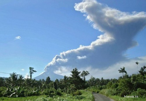
Volcanic eruption Gamkunoro |
|
Gamkunoro (1635 meters) is located in the northern part of the island. This is an active andesitic volcano 15 kilometers in diameter. Broken rejuvenated fault stretches north and south direction through the top of it. On the southern slope of the volcano on a line fault is gorge, where the river flows. Its sources are located in the crater. At the top is also a rift, bottom depth is 300 meters. One (1000 meters) is located southwest of the volcano Gamkunoro. Andesitic-dacitic extinct stratovolcano broken fault, extends in the east-west direction across the top. Rift at the break is filled with porous andesite lava To the north of the volcano Onu has large lava flows that extend to the west and east of the volcano. Its length is 10 kilometers. Lavas are acidic andesites and obsidian. Volcano Wounds (1000 meters) is located north-east of the Gulf of Jaylolo on the west coast of the island Halmahera. This caldera has a diameter of 3 kilometers. In the northern part of the explosive Crater Lake is located one kilometer wound. On the western shore of the lake are fumarole fields. Fumarole field is small and in the southern part of the caldera, and at the outer slope. North-west of the caldera is a young explosive crater 1,500 meters. Todoko-Sahu (979 meters) is located on the western shore of the island of Halmahera, the Bay Jaylolo. It is an ancient caldera Todoko diameter of 3 kilometers. |
 |
|
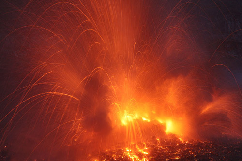
Volcanic eruption Dukono |
| Its bottom is filled with lava. In the south-eastern part, in the tract Telaga Pedoza (Wicked Lake), are numerous and solfataras mofetil. On the caldera is a young stratovolcano Sahu (1370 meters). Its slopes are complicated by side cones. So, on the southern slope of the cone of Honor (643 meters), and on the east - It's time (682 meters). In the south-eastern slope of the Sahu numerous hot springs. |
|
Halmahera Sea Halmahera Sea is inter-island sea of the Pacific, which is located between the islands of Halmahera, Obi and the Bird's Head Peninsula (the island of New Guinea). Sea area of 75,000 square kilometers, the average water depth is 747 meters, the maximum depth of the sea is 2072 meters. Sea surface temperatures range from 25, 7 ° C in August to 28, 6 ° C in May. The salinity of sea water is 34-34,6%. |
| Home | New Guinea | Kalimantan | Sumatra | Sulawesi | Java | Timor | Halmahera |